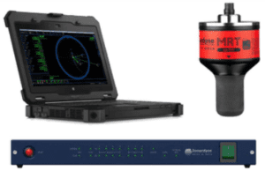
The Mission Specialist Navigation Package allows for a higher level of autonomous control. The package integrates a Doppler velocity log (DVL) which locks onto and tracks the ROV’s position along the sea bottom.
The DVL estimates distance travelled and calculates the current position with simple “dead reckoning” navigation.
A GPS antennae is used to correct the vehicle’s position when it’s on the surface.
These sensors are seamlessly integrated on the Defender through Greensea’s Balefire software with station keeping, requisition, mission planning, dynamic positioning, and data string export features.
A USBL system can added to the system and used on mission profiles where the sea bottom exceeds the operational range of the DVL.
Currently this package can only be added to a VideoRay Defender ROV.
Doppler velocity log (DVL) specification
| Depth rating | 300 metres |
|---|---|
| Frequency of operation | 1MHz |
| Beam width | 2.9° |
| Configuration | 4-beam Janus array convex transducer, 25° beam angle |
| Single ping std | 3m/s – 0.5cm/s |
| Minimum altitude | 0.2 metres |
| Maximum altitude | 75 metres |
Greensea upgrades
- Station keeping
- Reacquisition
- Mission planning
- Dynamic positioning
MAX-M8W GPS Mast
| Depth rating | 300 metres |
|---|---|
| Horizontal position accuracy | 2.5 metres |
| Time-to-first-fix | 29 seconds |
| Sensitivity | 166 dBm |